
Geo-tooling interoperability modules
Introduction
Welcome to the Geo-tooling interoperability user manual!
Are you tired of setting up geometries in different software packages, struggling to align them with 3D models, or copying CPT data between tools? Then you have come to the right place. Our Haskoning geopackage interoperability modules solve these issues.
The geo-tooling interoperability module aims to:
- Facilitate collaboration through data exchange with other disciplines, like structural engineers and computational modellers.
- Simplify the exchange of geotechnical data across various tools and software used in engineering projects.
Remember geo-tooling is here to assist you. Share your ideas or requests with us.
Built on the geo-package, part of DataFusr, our modules ensure interoperability between software packages, tools, and data platforms like Speckle and OpenGround.
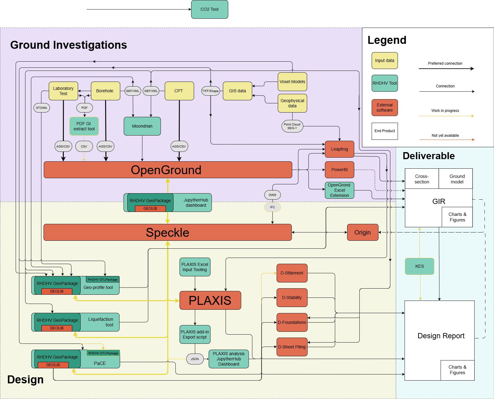
The interoperability scheme
The geo-package integrates various geotechnical engineering software tools to enable seamless dataflow between them. The process begins with the ground investigation data. Data in formats such as CSV, AGS, GEF, or PDF can be uploaded to OpenGround using available tools. OpenGround serves as a geotechnical database where all factual ground investigation data is stored. From OpenGround, data can be sent to Speckle. Speckle then distributes the data to different design software packages, such as Geo-profile, Plaxis, the liquefaction tool, or Jupyterhub dashboards. The final step of the workflow involves compiling images and calculation results into a report. The geo-package facilitates all these functions.
Note some of these connections are not operational yet. Please let us know which connections are required the most.
Getting started
General users
The geo-tooling team has tried to make everything as easy as possible. That means that geo-package is used without you knowing it. Geo-package is e.g. integrated in different Jupyterhub dashboards, getting data from Openground to Geoprofile, loading CPT data in the liquefaction tool, etc. More on this in our overview of the connectors in the [User manual](user manual).
Developers
In case you have some more Python knowledge and are ready to explore geopackage to its full capabilities, geopackage can be installed through PIP in your IDE.
pip install artifacts-keyring
pip install rhdhv_geo --extra-index-url=https://corporateroot.pkgs.visualstudio.com/_packaging/rhdhv-py/pypi/simple```
Please find more information in the [Developers manual](user manual)